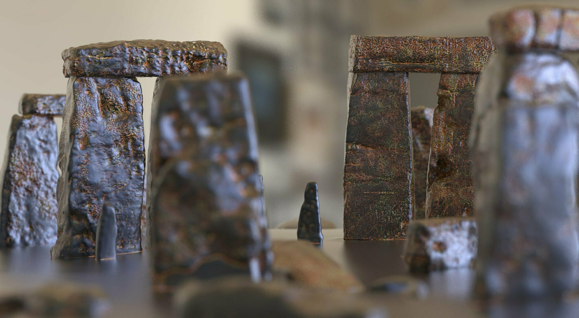
Artist first. AI user second. Geology A level third, and that was about forty-five years ago. Somewhere under the photography, the model-making and everything else, a little of it may still be rattling about.
So these are dreams, ideas, questions. Well beyond my pay grade. Developed in conversation with an AI model, checked against the documents where I can, and offered in the hope that somebody who actually knows this ground might see something worth following. Or spot where the wheels come off.
I am not putting together a research team. I am hoping a professional geologist might pick up the baton. There may be a good question here. It needs better hands than mine.
First, about that barrel…
In The Glacial A303, I got excited about forty litres of possible glacial evidence sitting in an archive. I had even imagined a blue plastic barrel. Very convincing, my imaginary barrel. A label. Probably a lid.
The record did not support it. I had muddled the contexts, helped along by an earlier AI reading. The original post now carries the correction and its date. My name is on the article; the mistake is mine to put right.
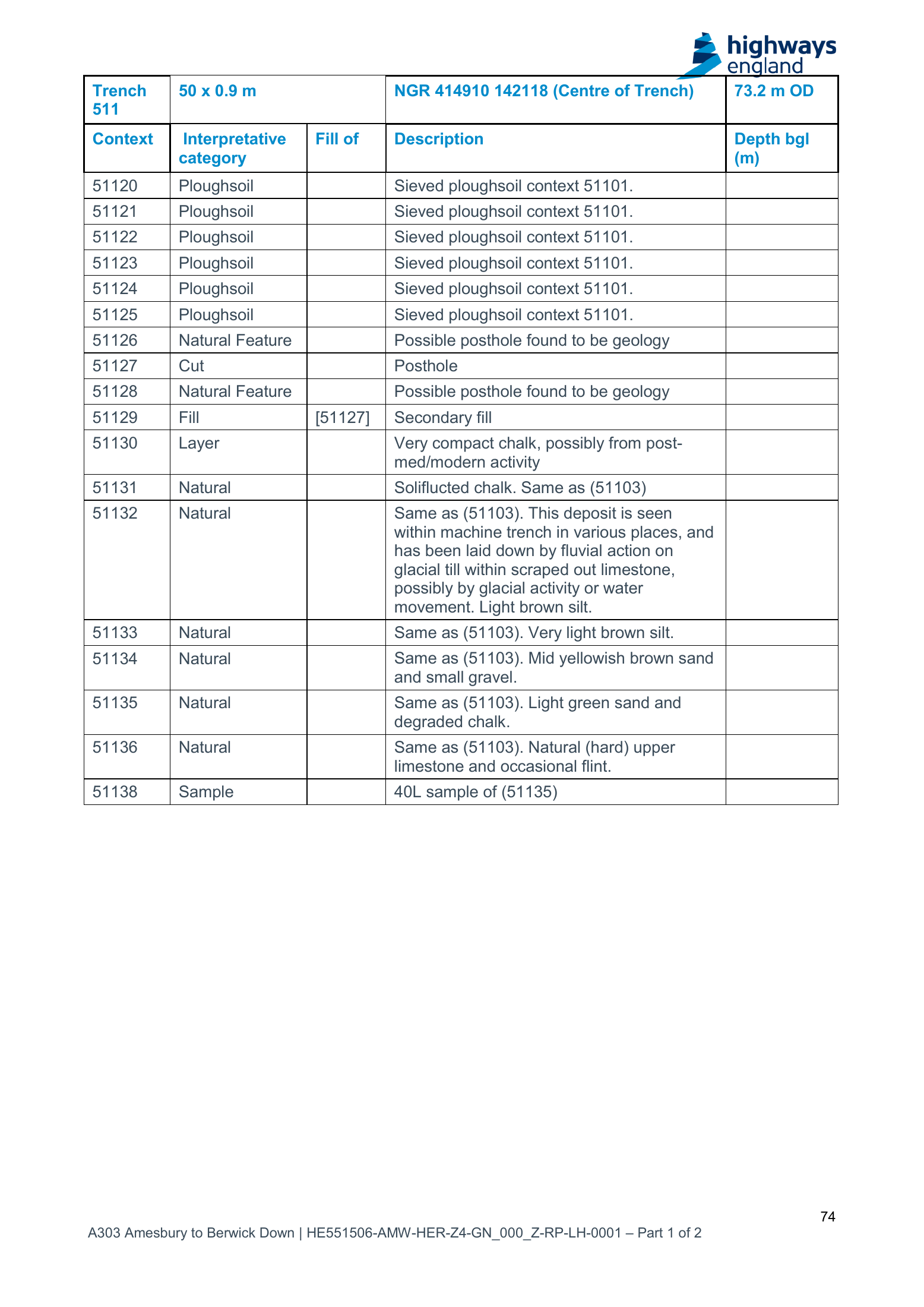
A context, before we go further, is an excavator’s separately recorded unit: a deposit, a cut, a feature. Its number lets the notes, drawings and samples refer to the same thing. A context number is not a geological diagnosis.
Here, 51132 carries the “glacial till” wording. Sample 51138 came from 51135, described as “light green sand and degraded chalk”. Both refer back to the broader natural sequence 51103. Related entries. Not interchangeable. The table is here, printed p. 74 / PDF p. 75.
Flot? Hang on. Explain that bit.
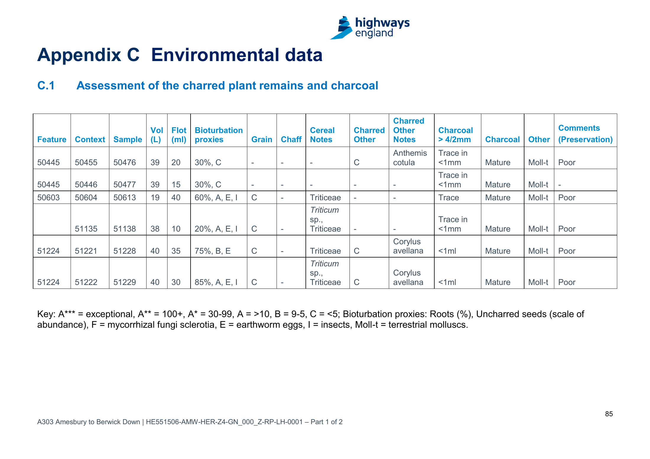
The environmental appendix records 38 litres processed and a 10 ml flot. Appendix C, printed p. 85 / PDF p. 86.
Flotation separates material by washing a soil sample in water. Light material floats and is caught in a fine sieve. That collected light fraction is the flot. Charred seeds and charcoal are among the things archaeologists hope to recover. Heavier material stays behind as the residue. MOLA explains the process here.
So the flot is one selected part of the sample. It is not the whole sample shrunk down. Ten millilitres is roughly two teaspoons. Two teaspoons of collected material, not two teaspoons representing everything that was in the original bucket.
Why look for that stuff? Because plant remains can help tell a story about crops, food and the environment people lived in. That was the archaeological job. Nobody had promised me a mineral-provenance survey. Historic England describes that wider purpose.
Provenance: where something came from. In this case, which rocks supplied the grains and fragments. Geology’s version of checking the delivery note. The awkward bit is that the parcel may have been forwarded several times.
What might still be left?
There is a sobering line in the processing method, printed p. 42 / PDF p. 43: coarse fractions above 4 mm were sorted, weighed and discarded. Whether any exception applied to this sample needs checking. The report is not a current inventory of the archive.
Perhaps something unprocessed survives. Perhaps a smaller residue, the flot, selected finds, photographs. Perhaps just the paperwork. I have no confirmation from Wessex. And forty minus thirty-eight does not conjure two surviving litres into existence.
If somebody qualified takes an interest, finding out what survives, where it went and how it was treated seems a sensible place to begin. They might immediately say that none of it suits the question. Fair enough. Better to find that out than build another argument round my barrel.
A road is a very thin way to sample a landscape
This needs saying loudly. The investigations were largely placed where the road scheme needed answers. They were not laid out to find the best surviving evidence of an ancient glacier.
My original survey plotted 698 recorded holes and trenches, with a few investigations elsewhere in the surrounding landscape. Sounds enormous. Put them on a map. Look at the gaps.
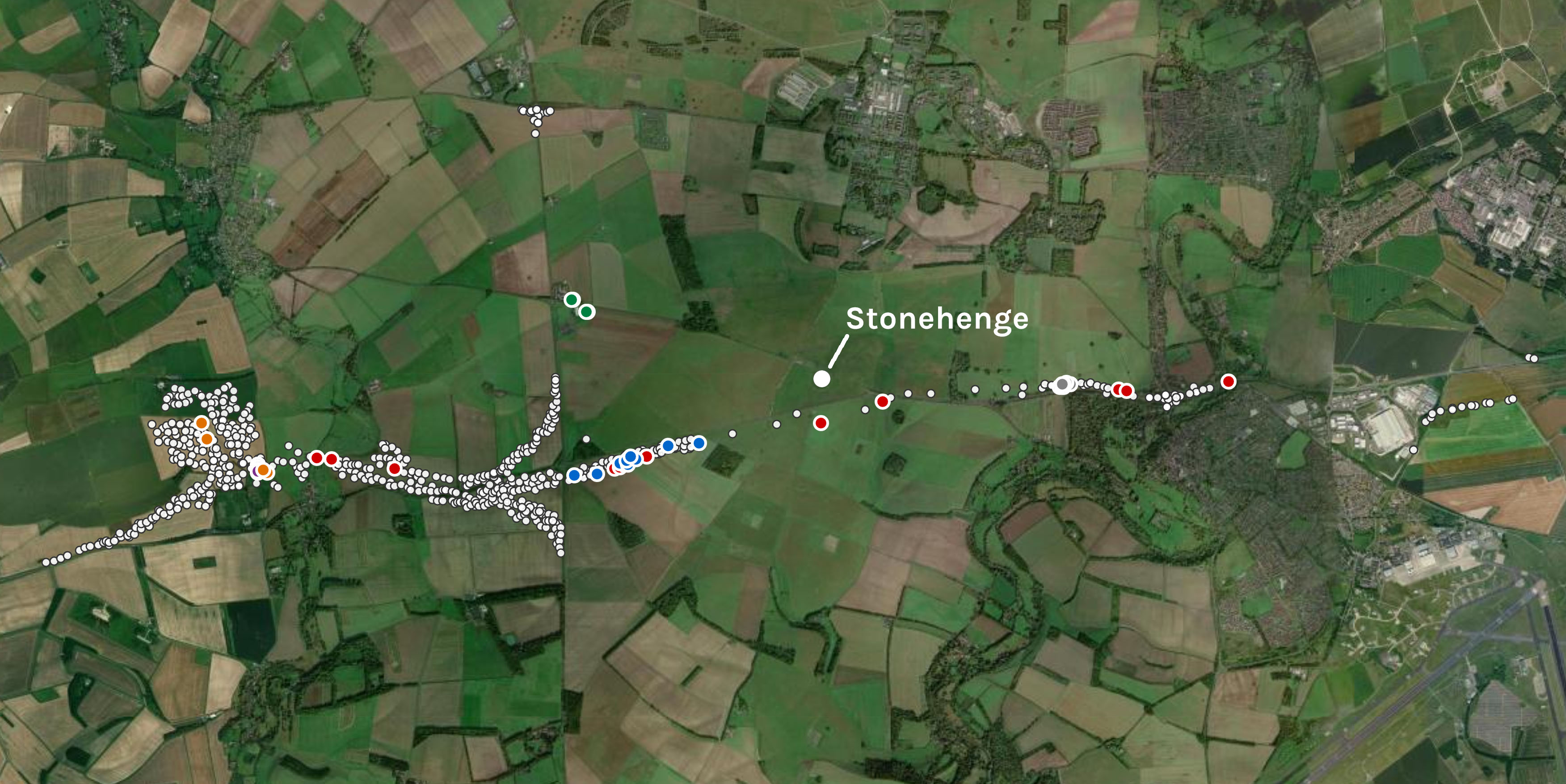
Each hole is a tiny view into the ground. Even a long trench samples a narrow strip. Between them, beyond them, under fields the proposed road never touched: a great deal of landscape. A tiny, tiny representation of what is out there.
That does not make the existing records worthless, and it does not turn the unsampled ground into evidence for ice. It means a geologist might see a much better place to look. A better-preserved sequence. A more informative exposure. Somewhere chosen for the geology, rather than the position of a future carriageway.
Trench 511 caught my eye because of words in a table. It has not earned the title of Best Place To Find A Glacier. I would be delighted if someone reading this could explain where a more useful question might be asked of the ground.
Preseli? Or the rest of the journey as well?
Here is the thought that keeps me interested. If ice brought material from the west or north, might a useful search look for more than a Preseli match? Other rocks. Other mineral populations. The company those grains keep.
An assemblage is simply that collection considered together. An erratic, in this discussion, is a rock fragment carried from its source by glacier ice. An unfamiliar pebble is not automatically an erratic; the means of transport is the very thing in question.
Could the mixture say more than one exciting grain? Could sources elsewhere in Wales, western England or northern Britain be relevant, perhaps Ireland if a defensible route made it relevant? These are the questions the AI conversation helped me reach. They are not a map of a journey I know happened.
There is a catch. A rock can come from far away and arrive here through several rounds of erosion and deposition. Old sediment becomes new sediment. Washed out, carried on, dropped again. The original address survives; the forwarding addresses go missing.
The BGS account of the Salisbury district describes residual deposits, river gravels and material moved downslope under cold conditions. Those local stores and processes give a geologist alternatives to test. Foreign to the Chalk does not necessarily mean delivered here by ice.
And the paper with the one grain?
Clarke and Kirkland’s January 2026 study analysed 550 zircons and 250 apatites from four modern stream-sand samples. Zircon and apatite are minerals; their grains can carry information about source rocks and geological history. The study uses uranium–lead dating: radioactive decay provides the clock.
Their one Wylye zircon at 464 ± 16 million years was potentially compatible with Preseli. Compatible is doing work there. The authors explain that comparable ages occur in recycled southern sediments. It was not a grain with “Preseli” printed underneath.
They examined broader northern signatures and sediment recycling too. Saying they only looked for Preseli would misrepresent the paper. They interpret their results as recycled sediment and conclude against Pleistocene glaciation of the Plain.
For me, the interesting follow-up is whether particular buried deposits might differ from that stream-sand background. They might not. Four samples should not be dismissed for being four, and an isolated deposit should not be assumed to have the same history without investigation. Whether that is a useful distinction here is a question for someone better equipped than me.
If there are any specialists out there… what about this?
Could any surviving material help? Could a fresh look at the field records untangle the deposits? Or would you leave this trench alone and start somewhere more promising?
If there were suitable material, might comparing it with ordinary local deposits help? A control is the comparison that stops the unusual-looking sample winning merely because it was the only one examined. Here, perhaps local residual deposits, valley sediment and river sand would provide that background. A specialist would know which comparisons are fair.
Would looking at rock fragments as well as individual minerals add anything? Petrography means examining what a rock is made of and how its minerals fit together, often in a very thin slice under a microscope. The AI suggested it as one possible way to investigate a fragment’s origin. Whether any suitable fragments survive is another matter.
And could the ground itself help distinguish the transport? Sedimentology looks at the deposit: grain sizes, sorting, layers, structures, relationships with what lies above and below. All the things that may help explain how it got there. A washed sample has lost its original arrangement. No amount of enthusiasm puts that back.
Would dating be possible, and what would the date actually mean? A mineral’s formation age is not the date it arrived near Stonehenge. The clock inside the grain and the journey of the grain are different stories. That is exactly the sort of distinction I need somebody to stop and explain.
None of this is a shopping list for a laboratory. These are suggestions emerging from an artist’s conversation with an AI. A professional might keep one, discard five, suggest something neither of us thought of. That would be a useful result from a blog post.
Somebody else’s baton
There are three puzzles tangled together. Where did the material originate? How and when did it arrive here? Does that tell us anything about the particular stones used at Stonehenge? Solving one does not automatically solve the others.
If the material turns out to be ordinary local sediment, that counts. If it is different, the difference still needs explaining. If the archive is empty, or another part of the landscape offers a better chance, the conversation moves there. There has to be room for the answer to disappoint my dreams.
I am an artist with an old A level, a pile of PDFs and an AI that has already helped me make one mistake and find it again. I can point at the paperwork. I can make the pictures readable. I can wonder.
Perhaps somebody reading this can go further. Not because I have set them a task. Because they see a question worth making their own.